Two Rounds of Severe Storms This Week
April 5, 2022Possible Freeze In Colder Upstate Locations This Weekend
A one-two punch of severe weather is on the way this week. Our weather remains quiet through tonight and early tomorrow, but then our first round of severe storms will hit South Carolina Tuesday.
Make sure you’re ready to deal with the severe storm and tornado threat. Being prepared and having a plan increases your odds of survival if faced with a tornado. SCEMD has a list of preparedness tips and safety rules to follow on their website, as does the National Weather Service. Here are the most important readiness precautions:
- Have at least two ways to be alerted, such as a phone weather app or weather radio.
- Be sure that these alert methods are correctly set up and will wake you if a warning is issued while you’re sleeping.
- Decide in advance where your best shelter area is before a storm strikes because you won’t have time to think about this when a tornado warning is issued for your area.
- If you live in a mobile home, find a place that is a suitable shelter that you can go to quickly in the event of a tornado.
- Secure or store any loose items in your yard due to the increased threat of strong winds.

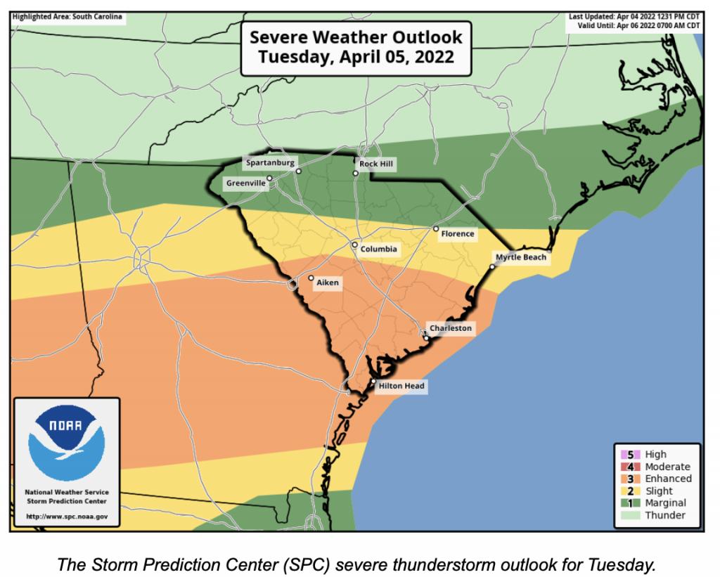
The entire state has the risk of seeing severe thunderstorms tomorrow, but the risk is most significant in the Lowcountry and vicinity, where the outlooks indicate risk level 3 of 5. When SPC puts you in risk level 3 for the tomorrow or Day 3 outlooks, it’s like a drill sergeant ordering us to attention; it’s potentially serious.
The culprit for this potential severe storm outbreak is a storm system currently passing over the Four Corners. It will menace the Southern Plains and lower Mississippi Valley this afternoon and tonight with severe thunderstorms, then march eastward through the Deep South and into South Carolina Tuesday.
One of the reasons for the higher level of concern for tomorrow is that the storm system will pass through during the afternoon and evening hours, which is the warmest and most unstable part of the day. The other is that a surge of warmth and moisture will head northward through the southeastern states ahead of the storm.
This will result in widespread thunderstorms, which will arrive in the Upstate and Central Savannah River Area (CSRA) early in the afternoon, marching east-southeastward across the state through the evening. The risk will be lower in the northern part of the state because clouds will limit daytime heating, while the Lowcountry will see breaks in the clouds at times, pushing temperatures into the 75-80°F range.
The primary concern will be damaging winds with the storm; however, the potential will exist for isolated tornadoes as well. It looks as though the greatest tornado threat will be in the Lowcountry and Pee Dee regions, where we will see the best combination of warm and unstable air with wind shear favorable for spinning storm updrafts and resulting tornadoes.
A front trailing this storm will turn stationary over the Lowcountry later Tuesday night into Wednesday morning, which will then retreat northward as a warm front later Wednesday into Wednesday evening. Wednesday will be unsettled due a scattering of showers and thunderstorms, but the severe storm risk during this time will be low despite temperatures peaking in the high 70s and lower 80s.
Then a cold front will move through later Wednesday night through Thursday, which will cause another round of thunderstorms, some severe. The timing of this event will be less favorable, but there is still a good bit of potential.
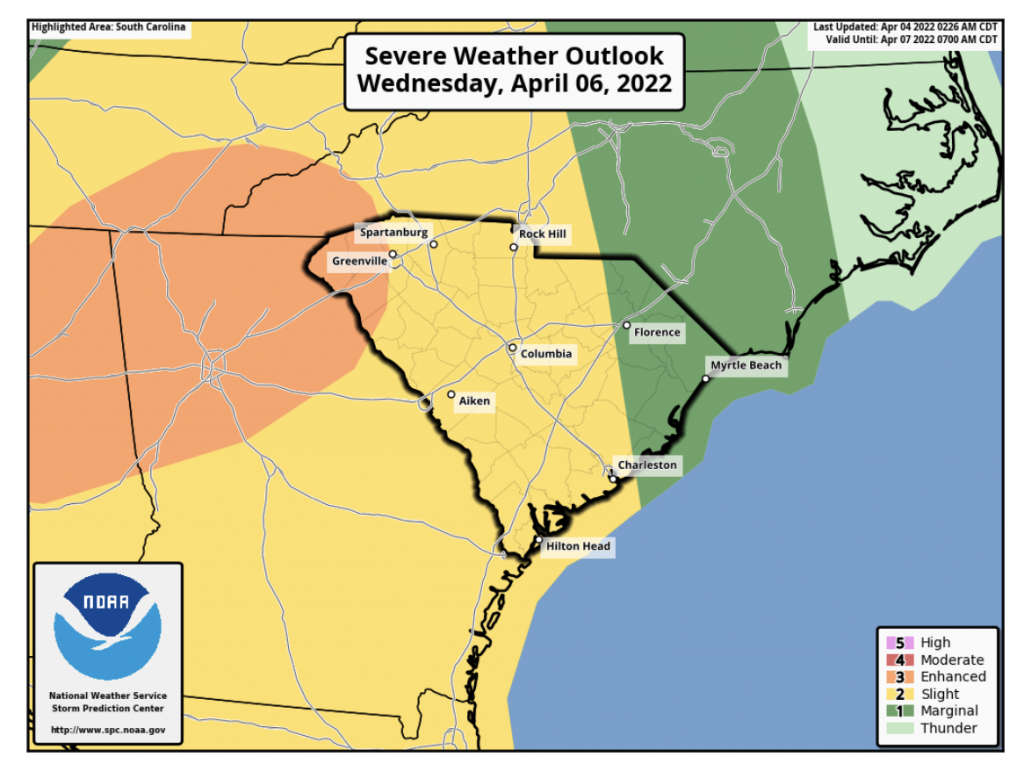
The SPC thunderstorm outlook for Wednesday.

The severe storms will get underway back in Mississippi and Alabama during the day Wednesday, consolidating into a line while passing through Georgia during the evening and then reaching South Carolina late in the evening or overnight. Once again, the primary concern is for damaging winds, but there can also be isolated tornadoes. The risk lingers through the first part of Thursday in the Pee Dee Region. As you can see from the outlook graphic, the greatest risk for this period, peaking at level 3 of 5 again, is over the far western part of the state. The risk level lessens to the east as the storms will likely diminish as they march eastward through the state late Wednesday night.
After the severe weather clears the state Thursday, unseasonably chilly air will invade the region. This will turn the weather’s calendar back to late February for a few days. Highs will be in the 50s and 60s despite a mainly sunny sky. Lows through the weekend will mostly be in the 30s and 40s. There is the threat of a freeze in the Upstate Sunday morning.

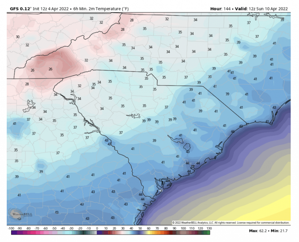
GFS model 2-meter (about 6.5 feet) low temperatures for Sunday morning
Most computer models show subfreezing temperatures in our mountain areas on Sunday morning, and some show temperatures falling to near freezing along I-85. Frost may be widespread over the Upstate, northern Midlands and northern CSRA on Sunday morning, thanks to a clear sky and light winds. So, you will likely have to take steps to protect tender vegetation if you have planted anything vulnerable to the cold.


