


Master Plan for Black River Park Network wins ASLA Award of Excellence for Analysis and Planning
October 19, 2022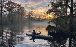
The Black River Water Trail & Park Network Master Plan was recognized by the South Carolina Chapter of the American Society of Landscape Architects with an Award of Excellence, one of the association’s highest awards that recognizes exemplary projects that reach beyond the project’s purpose.
The Purpose
The Open Space Institute (OSI) and South Carolina Parks Recreation and Tourism (SCPRT), with a steering committee of conservation partners and community members, commissioned a master plan to envision a series of linked riverside public and private parks along a 70-mile stretch of South Carolina’s Black River. Grassroots support from local river partners fueled the fire that generated the request for proposals to preserve, protect, and celebrate the valuable natural and cultural history of the greater Black River waterway for future generations.
The Team
The consultant team was tasked with providing a roadmap for the development of a series of public spaces where the connecting thread would be the Black River. Led by Earth Design — and guided by OSI’s Dr. Maria Whitehead, OSI’s Michaela Roberts (AICP), and SCPRT’s Terry Hurley — the team of Craig Gaulden Davis, Arnett Muldrow, and ADC Engineering documented a plan that explores recreational and educational opportunities along the river across Williamsburg and Georgetown counties and past historic communities including Kingstree, Andrews, and Choppee. The team gathered information to provide site analyses, community input, land use plans, and a final master plan of what the Black River Water Trail & Park Network could be.
An Inclusive Process
The effort is an example of how a project can engage communities in the planning process and give ownership to citizens who have experienced past marginalization. It’s a shining example of how multiple partners, who often have different needs, can come together to create something that is more than just the collective sum of the individual visions. Through the planning process, the team sought to provide equitable access for communities to not only be the benefactors of the plan, but also be equitable participants in its creation. Studied through the lens of conservation, the project provides opportunities to access a treasure known to many but enjoyed by few. The challenge was integrating the needs of national and local organizations from both public and private entities. The Black River Initiative brings together varied stakeholders into a focused effort to provide a planning resource that crosses generational and geographic boundaries.
See the OSI Storymap of the Black River Initiative: https://storymaps.arcgis.com/stories/5b83c49e41614dfabd8c2a5e2b686a24