


Richland County’s drone program continues reaching new heights
May 19, 2017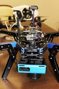
They may look like toys, but Richland County’s two drone units are anything but.
Each unmanned aerial system ― or UAS, but commonly called a drone ― is elevating the County’s ability to improve services, manage resources and save taxpayer dollars. The UAS program is led by Richland County Geographic Information Systems (GIS), a part of the Information Technology (IT) department. Four GIS employees are certified by the Federal Aviation Administration (FAA) to operate the aircraft, including Dr. Patrick Bresnahan, the lead geographic information officer overseeing the UAS program.
“These small autonomous platforms are just the next step in evolving technology for mapping sciences,” Bresnahan said. “In the past 20 years, we have moved from satellites, to airplanes, and now to small unmanned craft. With this evolution, the resolution of mapped objects has improved dramatically. Although our focus remains on mapping, a growing number of applications and requests can be satisfied quickly just because we have the gear and staff already in the field.”
UAS units can be used in a variety of ways. In Richland County, the units help:
- Promote economic development by providing detailed aerial footage of available business real estate
- Provide mapping data for various County departments, including the Assessor, Emergency Services and Planning
- Assess infrastructure damage from the October 2015 flood
- Gather information to help document construction of transportation program projects
- Collect elevation information to gauge capacity at the County landfill
The two commercial-grade UAS units have three-foot wingspans and weigh less than five pounds. At less than $2,500 each, their price tag is remarkably less than paying for aerial data recorded from staffed helicopters or airplanes. And, interchangeable cameras enable the units to record mission-specific information.

This week, GIS staff used the UAS equipment to photograph and map the Riverbanks Zoo pedestrian bridge and Shop Road extension, both projects funded by the transportation program.
“The return on investment with UAS mapping technology is significant,” Bresnahan said. “With staff already having backgrounds in remote sensing, the obvious step was to learn, train and become certified by the FAA to exploit this platform in our operations.”
Richland County’s UAS program adheres to all FAA regulations and safety guidelines, and the units are registered as small aircraft with the federal agency.
To learn more about the County’s UAS program, visit www.youtube.com/richlandonline to watch a video showcasing the units. To learn more about Richland County GIS, visit www.richlandmaps.com