


Lowvelo19 releases official bike routes
June 13, 2019
It’s a dream job in many ways. Organizing dozens of bike rides across the country, Chris Aronhalt gets to visit beautiful places. Topping the list of his favorite ones, though, is the inaugural LOWVELO bike ride Nov. 1-2 in Charleston as riders will get to sample some of the most scenic spots in the Lowcountry.
“This ride is going to be, first and foremost, one of the top rides across the country based on its world-class hospitality experience, and the cause to support the Hollings Cancer Center, so the combination of an incredible ride experience with an incredible cause is a win-win for the Charleston community,” says Aronhalt, managing partner of Medalist Sports. He says he’s excited to announce the three routes.
The ride, held Nov. 2, will feature 25-, 50- and 100-mile routes. Every rider-raised dollar goes to advance cancer research at the Medical University of South Carolina’s Hollings Cancer Center, the state’s only National Cancer Institute-designated cancer center.
Bolin says riders register for different reasons. Many have been touched by cancer either personally or through friends and family. “Most importantly, everyone visiting Charleston on Nov. 1-2 will be part of exclusive memorable moments with those whom they’ve been riding with and for.”
The following describes the special features of each route. All three will start at Riverfront Park, set on the banks of the Cooper River, the site of the opening ceremony held Friday night, Nov. 1.
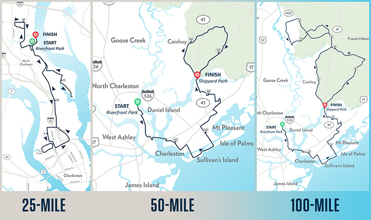
25 Mile
The 25-mile route suits all fitness levels and begins at Riverfront Park. From there, riders will travel south toward downtown Charleston. The route loops around the historic Hampton Park before reaching a rest stop at one of the most memorable landmarks in Charleston, The Citadel, where cadets will help refresh riders for the final leg of their ride. Riders will finish back where they started at Riverfront Park to the fanfare of supporters along the roadways and a big finale meal provided by Swig & Swine.
50 Mile
For those wanting more time in the saddle, LOWVELO’s 50-mile ride is a point-to-point route that includes going over “The Big Hill”, also known as the iconic Arthur Ravenel Jr. Bridge, with its sweeping views of the harbor, downtown historic Charleston and Fort Sumter. Riders travel through the Old Village in Mount Pleasant and then cross the Ben Sawyer Bridge to visit the island communities of Sullivan’s and Isle of Palms to enjoy marsh and beach views. Crossing the Isle of Palms Connector, an almost 4-mile long fixed span bridge, riders come back into Mount Pleasant to embark on the final leg of the journey. This part enters the pine-scented landscape of the Francis Marion National Forest, home to a variety of wildlife, including the endangered red-cockaded woodpecker, before looping back to Shipyard Park for a finale meal provided by Swig & Swine.
100 Mile
The Century route (100-miles) will follow the same pattern as the 50-mile route, beginning in Riverfront Park and ending at Shipyard Park, but will extend farther into the forests of Francis Marion National Forest. Century riders will bike through North Charleston, Charleston, Mount Pleasant, Sullivan’s Island, Isle of Palms, Cordesville and Berkeley County before coming to a well-deserved rest at the end at Shipyard Park to feast on a big finale meal provided by Swig & Swine.
Aronhalt says the ride features safety first and foremost. All routes will have Support and Gear (SAG) vehicles providing roadside assistance and MUSC Health will be providing first aid and emergency services for any health issues that may arise.
To learn more, visit LOWVELO.org.