


Richland County Flood Update Information
October 7, 2015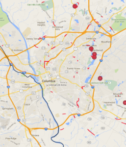
Flooding Overview Maps Now Online: The Richland County GIS team has worked with several partners to provide recovery and assessment support in the form of mapping information.
Several maps have been developed and are available at www.richlandmaps.com. This map page offers useful information for residents and the news media.
One of the maps, a flood inundation tool, features a spatial overview of the area that shows a “before and after” comparison of the County landscape. It offers a snapshot of conditions that are subject to change at any time.
Please note the maps are for informational purposes and should not be relied upon for current on-the-ground conditions. However, the Richland County GIS Department will update the information as conditions and time permit.
Visit richlandmaps.com or click here.
[youtube url=”https://youtu.be/-4Dc-gcqhfY”]
Also, video showing flooding in downtown Columbia and a flyover of parts of the County is available here.